

WW 642 TORNADO AL MS 182305Z – 190300Z URGENT – IMMEDIATE BROADCAST REQUESTED Tornado Watch Number 642 NWS Storm Prediction Center Norman OK 505 PM CST Thu Dec 18 2025 The NWS Storm Prediction Center has issued a * Tornado Watch for portions of Western and Northern Alabama Eastern Mississippi * Effective this Thursday afternoon …
Continue reading SPC Tornado Watch 642
Category:Weather
SPC MD 2263
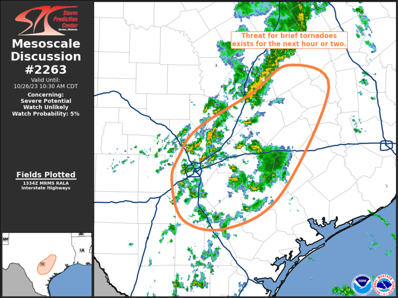
MD 2263 CONCERNING SEVERE POTENTIAL…WATCH POSSIBLE FOR EASTERN MS…WESTERN/NORTHERN AL…SOUTHERN MIDDLE TN Mesoscale Discussion 2263 NWS Storm Prediction Center Norman OK 0436 PM CST Thu Dec 18 2025 Areas affected…eastern MS…western/northern AL…southern Middle TN Concerning…Severe potential…Watch possible Valid 182236Z – 190000Z Probability of Watch Issuance…60 percent SUMMARY…Increasing potential for a tornadic supercell or two appears …
Continue reading SPC MD 2263
SPC MD 2262
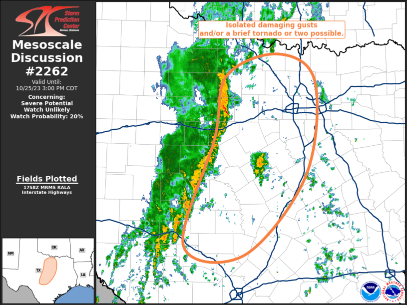
MD 2262 CONCERNING SEVERE POTENTIAL…WATCH UNLIKELY FOR EASTERN ARKANSAS INTO NORTHERN MISSISSIPPI…WESTERN TENNESSEE…WESTERN KENTUCKY…AND SOUTHERN INDIANA Mesoscale Discussion 2262 NWS Storm Prediction Center Norman OK 0348 PM CST Thu Dec 18 2025 Areas affected…Eastern Arkansas into northern Mississippi…western Tennessee…western Kentucky…and southern Indiana Concerning…Severe potential…Watch unlikely Valid 182148Z – 182345Z Probability of Watch Issuance…20 percent SUMMARY…Sporadic …
Continue reading SPC MD 2262
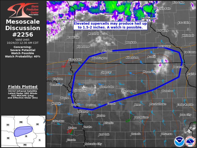
SPC MD 2261
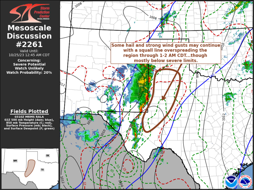
MD 2261 CONCERNING BLIZZARD FOR SOUTHERN MINNESOTA Mesoscale Discussion 2261 NWS Storm Prediction Center Norman OK 0223 PM CST Thu Dec 18 2025 Areas affected…Southern Minnesota Concerning…Blizzard Valid 182023Z – 190030Z SUMMARY…Patchy blizzard conditions are spreading southeast into south-central Minnesota and may persist for several hours. DISCUSSION…Recent surface observations from across south-central MN have begun …
Continue reading SPC MD 2261
SPC MD 2260
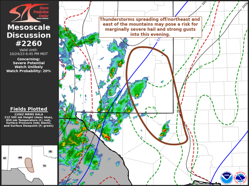
MD 2260 CONCERNING SEVERE POTENTIAL…WATCH UNLIKELY FOR EASTERN MISSOURI INTO SOUTHWEST ILLINOIS AND WESTERN KENTUCKY Mesoscale Discussion 2260 NWS Storm Prediction Center Norman OK 1044 AM CST Thu Dec 18 2025 Areas affected…Eastern Missouri into southwest Illinois and western Kentucky Concerning…Severe potential…Watch unlikely Valid 181644Z – 181845Z Probability of Watch Issuance…5 percent SUMMARY…A band of …
Continue reading SPC MD 2260
SPC MD 2259
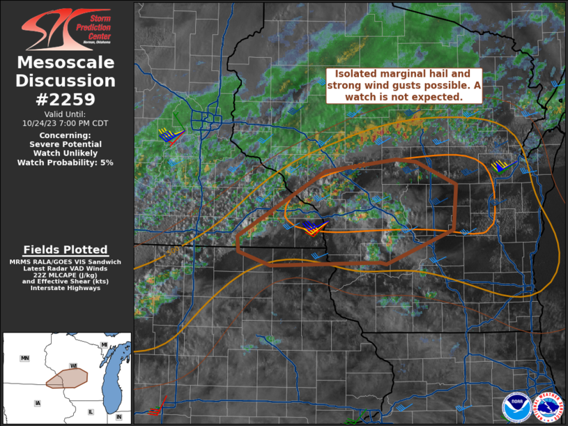
MD 2259 CONCERNING BLIZZARD FOR THE EASTERN DAKOTAS INTO WEST AND NORTHWEST MINNESOTA Mesoscale Discussion 2259 NWS Storm Prediction Center Norman OK 0909 AM CST Thu Dec 18 2025 Areas affected…The Eastern Dakotas into west and northwest Minnesota Concerning…Blizzard Valid 181509Z – 182015Z SUMMARY…Blizzard conditions are expected to continue across parts of the eastern Dakotas …
Continue reading SPC MD 2259
SPC MD 2258
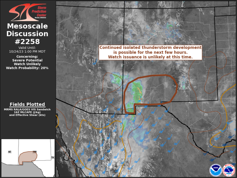
MD 2258 CONCERNING HEAVY SNOW FOR FAR SOUTHEAST IA…CENTRAL IL…AMD WEST-CENTRAL IN Mesoscale Discussion 2258 NWS Storm Prediction Center Norman OK 0943 AM CST Sat Dec 13 2025 Areas affected…far southeast IA…central IL…amd west-central IN Concerning…Heavy snow Valid 131543Z – 131945Z SUMMARY…A band of moderate to heavy snow with bursts of rates around 1 inch …
Continue reading SPC MD 2258
SPC MD 2257

MD 2257 CONCERNING HEAVY SNOW FOR PORTIONS OF CENTRAL INTO EASTERN NEW YORK Mesoscale Discussion 2257 NWS Storm Prediction Center Norman OK 0807 AM CST Wed Dec 10 2025 Areas affected…portions of central into eastern New York Concerning…Heavy snow Valid 101407Z – 101800Z SUMMARY…Moderate to heavy snow is expected to persist into the late morning …
Continue reading SPC MD 2257
SPC MD 2256
MD 2256 CONCERNING HEAVY SNOW FOR EASTERN MINNESOTA…WESTERN/CENTRAL WISCONSIN Mesoscale Discussion 2256 NWS Storm Prediction Center Norman OK 0712 PM CST Tue Dec 09 2025 Areas affected…eastern Minnesota…western/central Wisconsin Concerning…Heavy snow Valid 100112Z – 100415Z SUMMARY…Heavy snow to continue through the evening with occasional 1″/hr rates. DISCUSSION…Heavy to moderate snow continues to be reported across …
Continue reading SPC MD 2256
SPC MD 2255

MD 2255 CONCERNING HEAVY SNOW FOR PORTIONS OF NORTHERN INTO CENTRAL MINNESOTA Mesoscale Discussion 2255 NWS Storm Prediction Center Norman OK 1156 AM CST Tue Dec 09 2025 Areas affected…portions of northern into central Minnesota Concerning…Heavy snow Valid 091756Z – 092300Z SUMMARY…Moderate to heavy snow is expected to begin over the next few hours. 1 …
Continue reading SPC MD 2255