
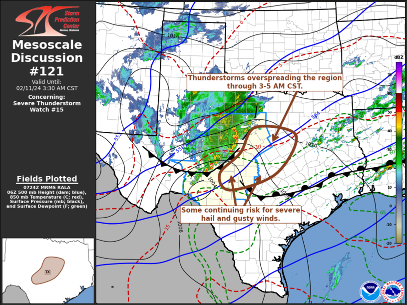
MD 0121 CONCERNING SEVERE POTENTIAL…WATCH POSSIBLE FOR PARTS OF THE EASTERN TX PANHANDLE INTO WESTERN OK AND WESTERN NORTH TX Mesoscale Discussion 0121 NWS Storm Prediction Center Norman OK 0114 PM CST Sun Mar 02 2025 Areas affected…Parts of the eastern TX Panhandle into western OK and western north TX Concerning…Severe potential…Watch possible Valid 021914Z …
Continue reading SPC MD 121
Category:Weather
SPC MD 120

MD 0120 CONCERNING SEVERE POTENTIAL…WATCH UNLIKELY FOR PARTS OF INDIANA AND OHIO…AND FAR NORTHERN KENTUCKY Mesoscale Discussion 0120 NWS Storm Prediction Center Norman OK 0319 PM CST Thu Feb 27 2025 Areas affected…parts of Indiana and Ohio…and far northern Kentucky Concerning…Severe potential…Watch unlikely Valid 272119Z – 272345Z Probability of Watch Issuance…5 percent SUMMARY…Damaging gusts and …
Continue reading SPC MD 120
SPC MD 119

MD 0119 CONCERNING SEVERE POTENTIAL…WATCH UNLIKELY FOR NORTHERN OREGON…SOUTHERN WASHINGTON Mesoscale Discussion 0119 NWS Storm Prediction Center Norman OK 0643 PM CST Mon Feb 24 2025 Areas affected…Northern Oregon…Southern Washington Concerning…Severe potential…Watch unlikely Valid 250043Z – 250245Z Probability of Watch Issuance…5 percent SUMMARY…Potential for a few gusts, some of which could be severe, over the …
Continue reading SPC MD 119
SPC MD 118

MD 0118 CONCERNING HEAVY SNOW FOR PORTIONS OF NORTHERN/NORTHEAST NORTH CAROLINA INTO SOUTHEAST VIRGINIA Mesoscale Discussion 0118 NWS Storm Prediction Center Norman OK 1208 PM CST Wed Feb 19 2025 Areas affected…Portions of northern/northeast North Carolina into southeast Virginia Concerning…Heavy snow Valid 191808Z – 192315Z SUMMARY…Snowfall rates around 1 in. per hour are possible within …
Continue reading SPC MD 118
SPC MD 117

MD 0117 CONCERNING FREEZING RAIN FOR PORTIONS OF NORTH AND SOUTH CAROLINA Mesoscale Discussion 0117 NWS Storm Prediction Center Norman OK 1204 PM CST Wed Feb 19 2025 Areas affected…portions of North and South Carolina Concerning…Freezing rain Valid 191804Z – 192300Z SUMMARY…Freezing rain with rates of 0.05-0.1 in/hr appear likely over parts of the Carolinas …
Continue reading SPC MD 117
SPC MD 116

MD 0116 CONCERNING HEAVY SNOW FOR NORTHEASTERN ARKANSAS…SOUTHEASTERN MISSOURI…WESTERN TENNESSEE…WESTERN KENTUCKY…SOUTHERN ILLINOIS Mesoscale Discussion 0116 NWS Storm Prediction Center Norman OK 0601 PM CST Tue Feb 18 2025 Areas affected…Northeastern Arkansas…Southeastern Missouri…Western Tennessee…Western Kentucky…Southern Illinois Concerning…Heavy snow Valid 190001Z – 190300Z SUMMARY…Snowfall rates will gradually increase across portions of western Kentucky and western Tennessee through …
Continue reading SPC MD 116
SPC MD 115
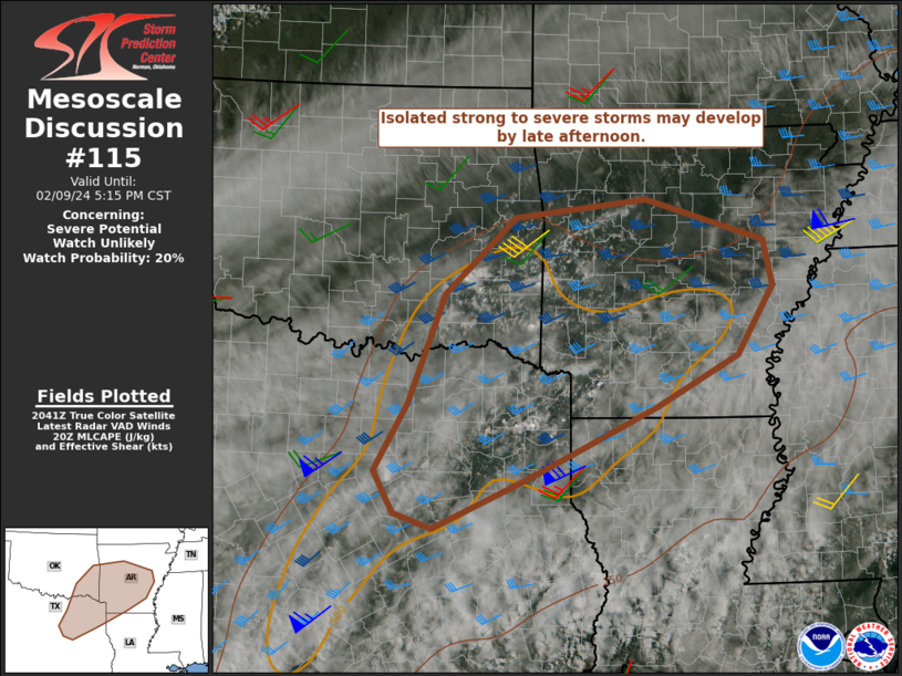
MD 0115 CONCERNING WINTER MIXED PRECIPITATION FOR EAST-CENTRAL OKLAHOMA INTO CENTRAL ARKANSAS Mesoscale Discussion 0115 NWS Storm Prediction Center Norman OK 1233 PM CST Tue Feb 18 2025 Areas affected…East-central Oklahoma into central Arkansas Concerning…Winter mixed precipitation Valid 181833Z – 182230Z SUMMARY…Freezing rain and sleet are possible from east-central Oklahoma into portions of central Arkansas. …
Continue reading SPC MD 115
SPC MD 114

MD 0114 CONCERNING HEAVY SNOW FOR PORTIONS OF SOUTHEASTERN KS…FAR NORTHEASTERN OK AND THE OZARK PLATEAU Mesoscale Discussion 0114 NWS Storm Prediction Center Norman OK 1220 PM CST Tue Feb 18 2025 Areas affected…portions of southeastern KS…far northeastern OK and the Ozark Plateau Concerning…Heavy snow Valid 181820Z – 182345Z SUMMARY…Snowfall rates are expected to increase …
Continue reading SPC MD 114
SPC MD 113

MD 0113 CONCERNING WINTER MIXED PRECIPITATION FOR PARTS OF CENTRAL/EASTERN OK INTO NORTHWEST AR AND EXTREME SOUTHWEST MO Mesoscale Discussion 0113 NWS Storm Prediction Center Norman OK 0748 AM CST Tue Feb 18 2025 Areas affected…Parts of central/eastern OK into northwest AR and extreme southwest MO Concerning…Winter mixed precipitation Valid 181348Z – 181645Z SUMMARY…Light to …
Continue reading SPC MD 113
SPC MD 112

MD 0112 CONCERNING HEAVY SNOW FOR CENTRAL KANSAS Mesoscale Discussion 0112 NWS Storm Prediction Center Norman OK 1155 PM CST Mon Feb 17 2025 Areas affected…Central Kansas Concerning…Heavy snow Valid 180555Z – 180900Z SUMMARY…Heavy snowfall with occasional rates of 1″/hr. DISCUSSION…Snowfall coverage has increased across portions of central Kansas as upper-level forcing overspreads the central …
Continue reading SPC MD 112